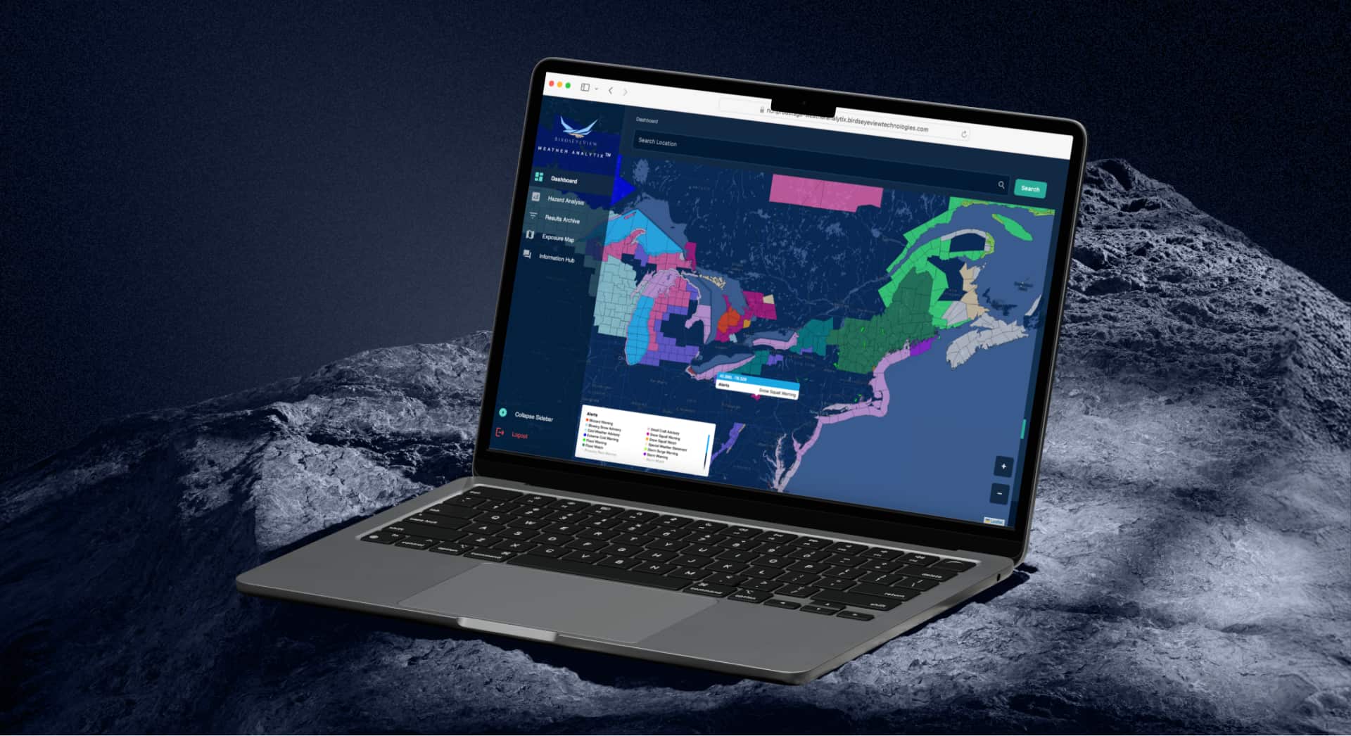

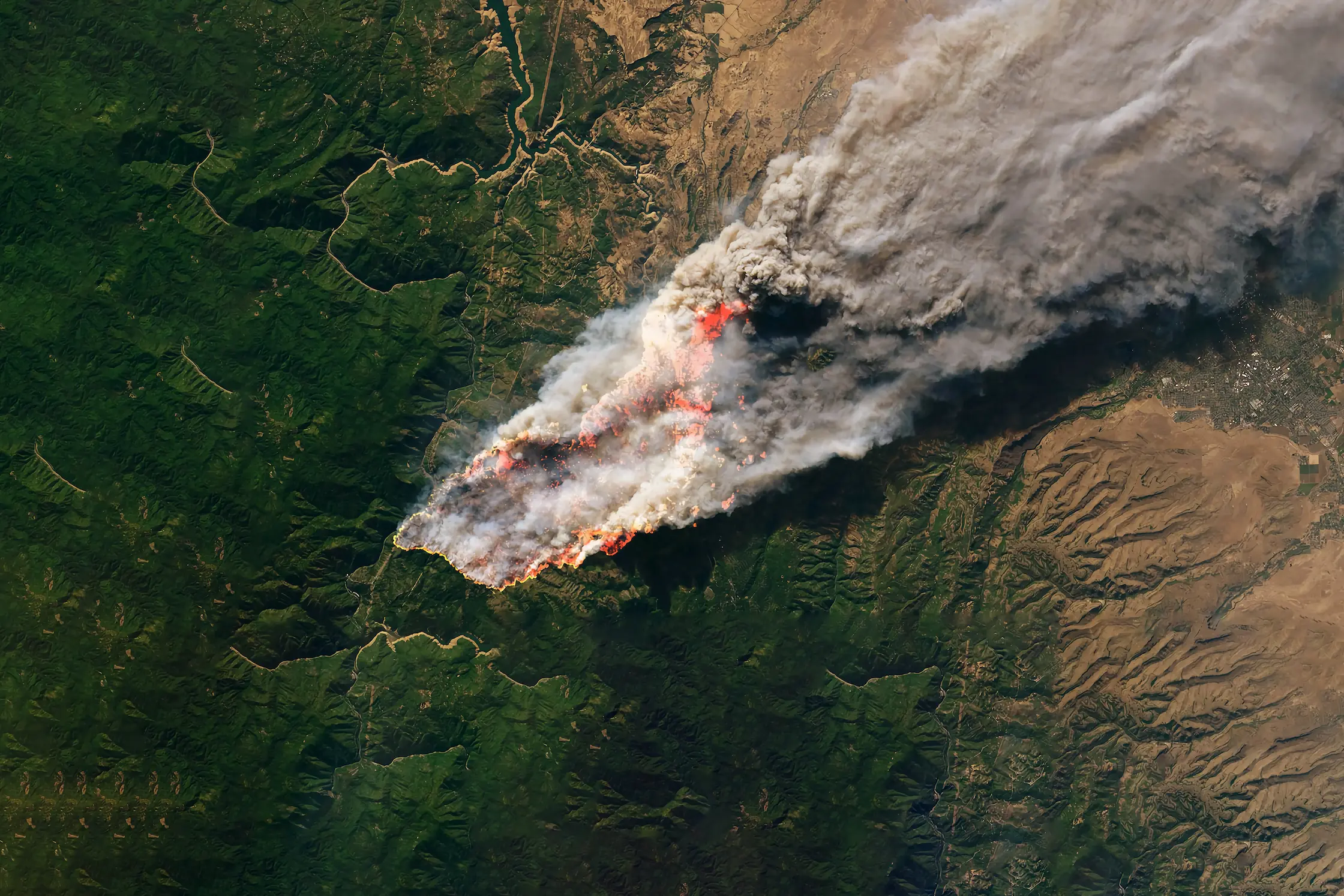
The Data Behind the Fire: A Look Into Our Wildfire Model
Wildfires now result in nearly 6 million more hectares of tree cover loss per year than in 2001, an area the size of Croatia.
Feb 19, 2026

A Look at Lightning: Our Experts Explore Our In House Model
This article explores how BirdsEyeView’s high-resolution modelling addresses the $1 billion annual cost of lightning claims by providing granular, microsecond-accurate data for insurers. Using real-world examples like the "Eras Tour" delays, it demonstrates how shifting from coarse regional maps to precise, 5km-grid analytics is essential for modern property and contingency underwriting.
US insurers paid out $1.04 billion in lightning-related property insurance claims according to the Insurance Information Institute. With the US National Weather Service reporting approximately 25 million cloud to ground lightning strikes every year, the danger extends far past the immediate damage. On top of causing serious infrastructure damage, lightning is a leading ignition source of wildfires globally. In our last BirdsEyeView newsletter we discussed lightning being the leading cause of wildfires outside of human influence.
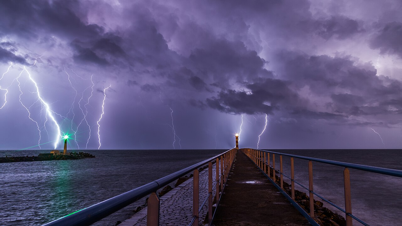
Lightning is a costly and unpredictable weather event that creates immense volatility for insurers.
Being informed by expert models can give insurers a decisive advantage in insuring lightning prone areas. As companies and individuals invest in lightning protection across the globe, increasing the quality of modelling and data surrounding lightning can help policyholders prevent damage, mitigating the ever increasing cost to insurers from lightning.
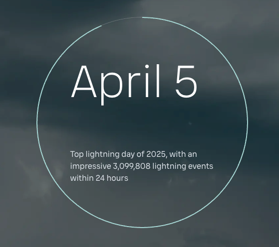
In 2025 there was a 20% increase in lightning strikes in the US, this is an eight year high. Globally, over 2 billion lightning events were detected by Xweather. Xweather is a company that focuses on real time weather alerts and storm monitoring. They utilise a network of sensors globally that allow them to provide storm alerts with 99.9% accuracy. Xweather stated that “Lightning caused 11 confirmed delays across NFL and NCAA football games in 2025, including the NFL season opener, Eagles vs Cowboys in Philadelphia, PA. The most significant incident occurred on September 13th during an NCAA football game at Ross-Ade Stadium in West Lafayette, IN, where 1,800 lightning events within 10 miles forced a full evacuation and 90-minute delay”.
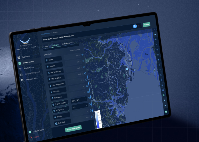
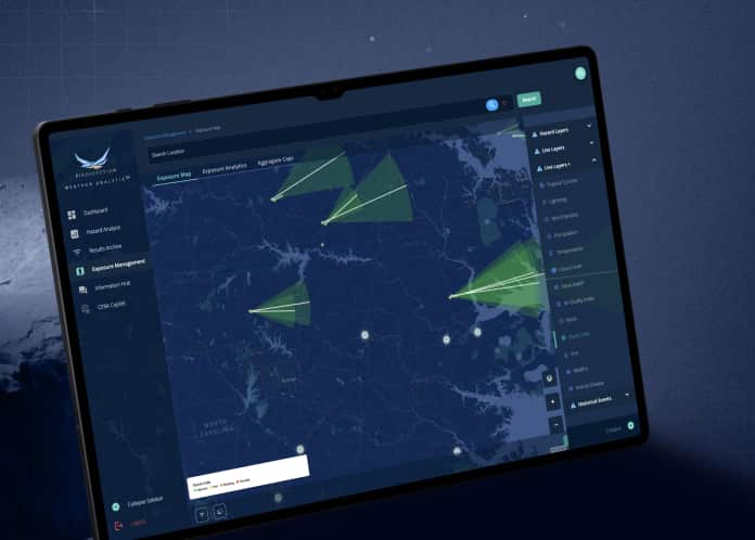
When evaluating the risk from lightning, there have long been issues associated with producing maps that are of high quality. The key problems come from generating maps that are capable of accurately describing both lightning occurrence and frequency while also simultaneously giving precise information relevant for individual locations (rather than over regions). Simply put, if a lightning risk model is too coarse to provide detail useful for an individual event or property, its value is diminished.
As some insurers are required to consider the likelihood of a site being hit directly by a lightning stroke or being caught up in its associated storm, the more granular a lightning risk model’s insights are the better. This can either come in the form of higher spatial resolution (e.g., town vs district scale), or from a more precise tracking of when exactly lightning strokes are detected, tracked, and therefore expected (e.g., hours vs. days).
For some insurers, it is common to require both - to know how likely a site and its surrounding area are to being hit by lightning (typically within a 5-10km radius around a site) and also understanding the risk profile within a very specific time window (e.g., the 2nd to 5th July between 6 and 10pm each day). This kind of requirement justifies a more comprehensive lightning risk model than has typically been available in the market for insurers.
Lightning is recognised as a weather peril due to its ability to transfer extremely high voltage of energy through its strokes as a rapid energy release (a plasma channel reaching temperatures 5-6x that of the surface of the sun). This poses a dangerous threat to people’s lives, especially during outdoor and open events. This can lead to the triggering of safety protocols and potential evacuations for people, while also being capable of causing significant damage to infrastructure and equipment through direct strikes and induced electrical surges.
A fascinating and often dramatic weather phenomena, lightning typically occurs within storm systems and consists of discharges of electricity between two charged regions. This can be between two regions within the atmosphere (inter- or intra-cloud lightning) seen in clouds, or between a cloud and the ground (cloud-ground lightning). This forms a lightning channel of plasma and the surrounding air expands explosively from the stroke’s heat (and then rapidly contracts as it cools). This creates a powerful shockwave, thunder, which ripples through the air and can be heard up to 10 miles away (16 km).
Since lightning can strike outward roughly the same distance as the sound travels from a thunderstorm, hearing thunder can act as a meaningful indicator for whether you are in striking distance from a storm.
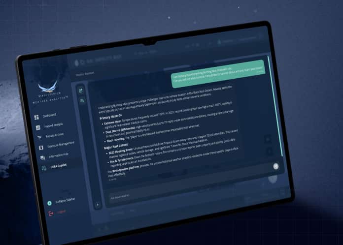
BirdsEyeView models lightning by using a proprietary lightning detection dataset which uses a network of sensors to detect atmospheric radio frequencies from electromagnetic pulses emitted by these strokes. Positioned across the globe, these sensors are capable of detecting strokes thousands of kilometers away down to the microsecond. This is achieved by multiple ground-based sensors in different areas of the globe and geolocating a stroke’s origin with its time of arrival.
BirdsEyeView processes this into a globally complete, high resolution gridded dataset to give daily localised insights, making adjustments to account for detection efficiency, spurious residuals and propagation artefacts for quality assurance.
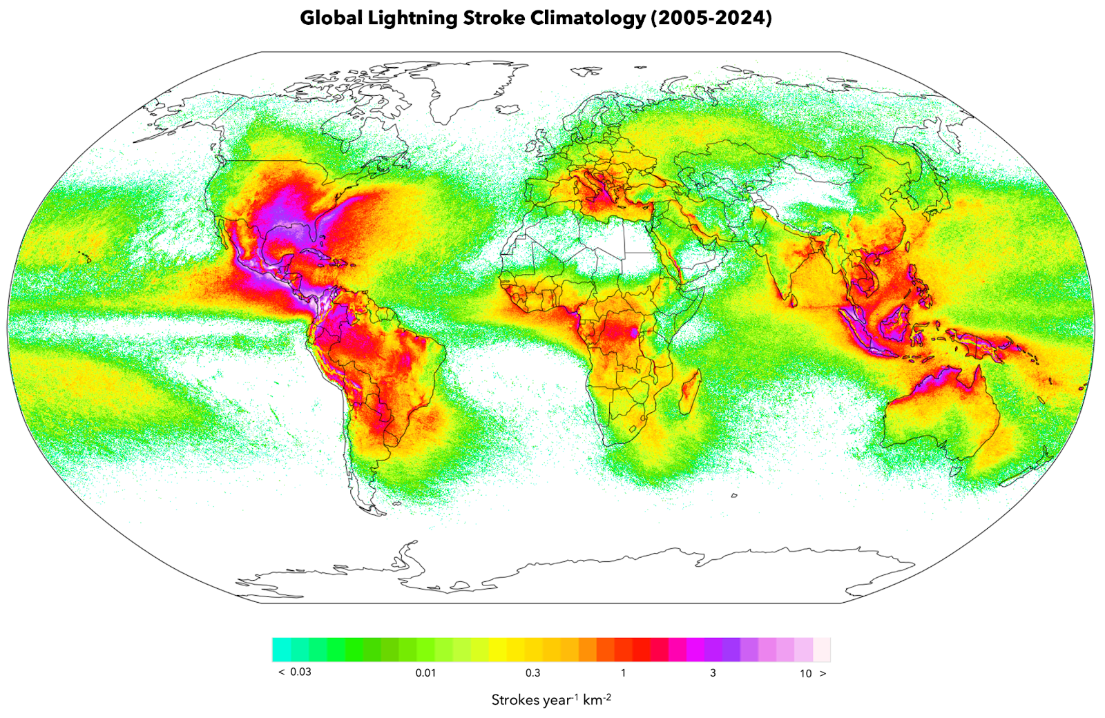
BirdsEyeView’s global lightning stroke climatology map (2005-2024) gridded to 5km.
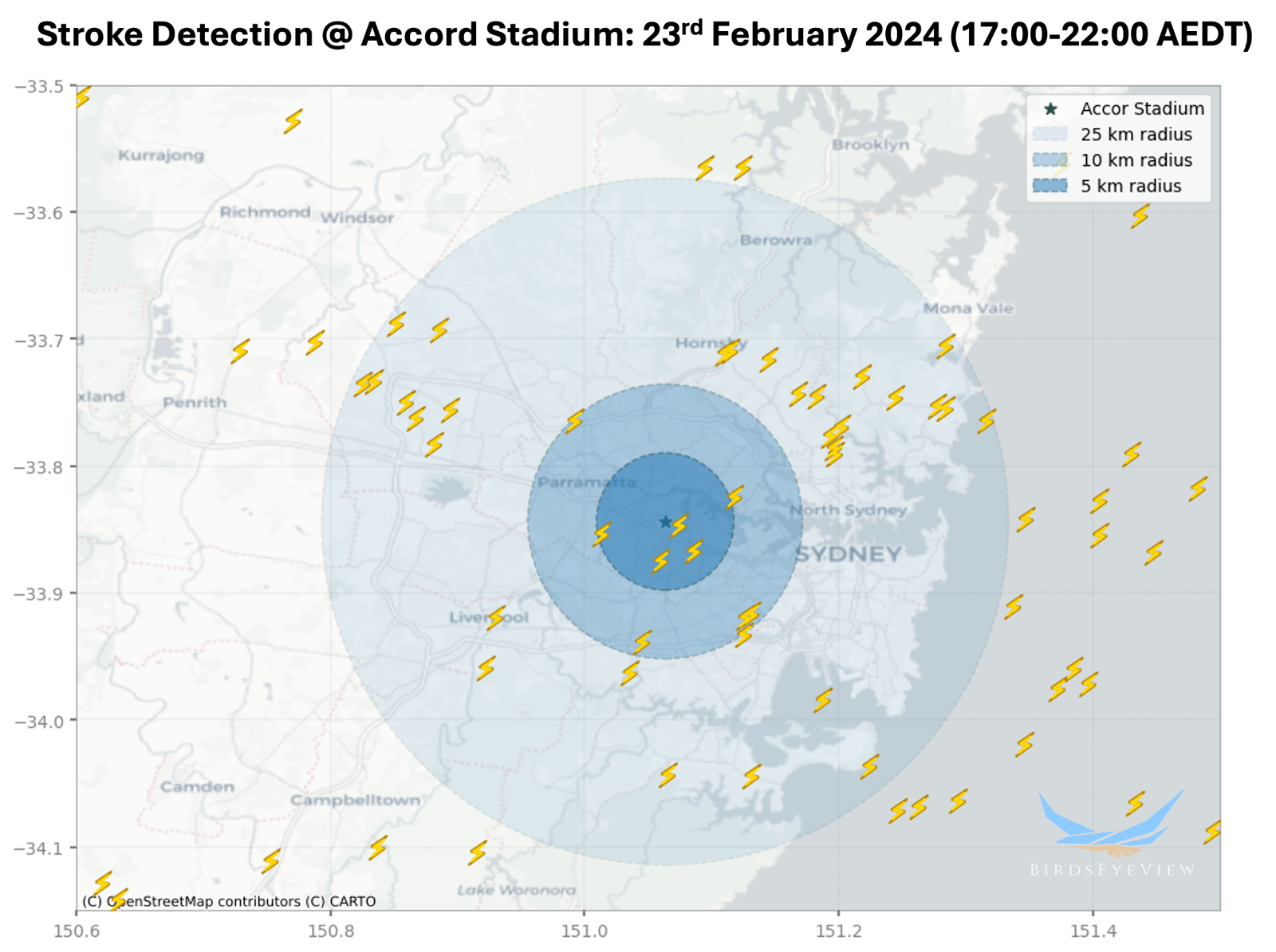
A high-profile event that experienced lightning-related delays was during Taylor Swift’s Eras tour, with a show being severely delayed with her opening act being cancelled due to the threat of lightning. The show had to be evacuated until the danger had passed and could resume. The financial repercussions of this kind of show being cancelled is significant to insurers. Therefore, having an accurate, granular model that can mitigate this kind of disruption is essential to insurers in dealing with lightning.
Using BirdsEyeView’s lightning data, the presence of lightning during the time period over which the event occurred and just prior (roughly 17:00-22:00 AEDT), showed several strikes within a 5km radius, with significantly more strokes detected over a 10 and 25km range. If modelled for a future event (in the year ahead), this type of historical lightning stroke occurrence informs and elevates the level of risk in the area.
Lightning is particularly relevant for property, contingency and energy insurers as their lines of business are disproportionally affected by lightning.Making investments into lightning protection as well as being informed about the risk that lightning can pose are important to insurers.

BirdsEyeView Secures Seven-Figure Investment to Accelerate Global Expansion
BirdsEyeView, the European Space Agency-backed insurtech specializing in natural catastrophe modelling and exposure management, has secured an undisclosed seven-figure investment to support the company’s continued international growth and ongoing product development.
Have questions about CERA®, integrations, pricing, or use cases for your organization? Our specialists can walk you through the platform and recommend the right solution.
.webp)